
Heading into the hills for a good hike can be the absolute highlight of my any outdoor enthusiast’s week, but finding your way safely along the route is always front of mind. Knowing exactly where you are and where you’re headed just makes the whole adventure easier to enjoy. With a few helpful tools and some straightforward tips, figuring out trails is simpler than ever, even if you’ve never used a classic paper map or compass.
The Value of Reliable Navigation When Hiking
Relying on solid navigation doesn’t just keep you from getting lost—it also plays a big part in safety and lets you actually soak up the scenery without constantly worrying about directions. Plenty of stories have focused on blaming people for wandering off course, but that’s not really useful. Sometimes, challenging conditions, tough signage, or quick weather switches can confuse anyone, no matter how much experience they have.
I seriously admire the dedicated mountain rescue teams who lend a hand when trouble hits. These volunteers put in hours of effort, rescuing hikers time and again. I want to support their work by using the best navigation tools possible and spreading the word so more people stay safe on the trails.
Modern Navigation Tools: Why Smartphones Make Sense
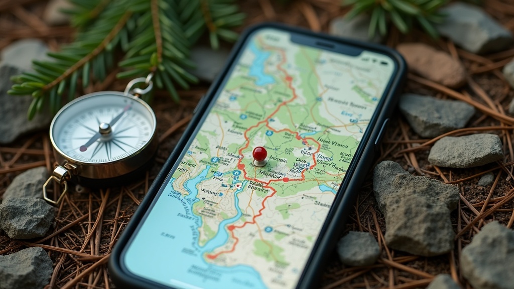
I bring my smartphone on every hike, and honestly, for most people it’s the best navigation choice around. The old rule about “always carry a map and compass” made sense before GPS became a pocket essential. Mastering maps and compasses takes time, and most people never need those skills except during emergencies.
Apps like AllTrails, Gaia GPS, and OutdoorsGPS have changed the way I plan walkes. They let me snag detailed trail maps—even with elevation data and route highlights that make planning a breeze. If I map out my route ahead of time and save it for offline use, my GPS still works even in the middle of nowhere or past the last cell tower. That’s because the GPS in a phone connects to satellites directly, so I don’t need an internet connection to know where I stand.
- Offline Maps: Always download your hiking area ahead of time to avoid surprises if there’s no signal.
- Route Tracking: These apps keep a record of your walk, making backtracking easy if needed.
- Elevation and Distance Data: Extra stats about your hike can help you schedule breaks or spot major landmarks.
For those new to hiking, navigation apps tend to be much more accessible and far less overwhelming compared to figuring out topographic lines or using a compass. I always tell friends: start with your smartphone. It’s friendly and makes trip planning a whole lot smoother.
Common Concerns About Relying on Smartphones for Hiking Navigation
Some folks have doubts about taking just a phone into the wild, but most of the classic worries are easier to handle than you might think. Here’s what I’ve learned over countless hikes:
- Rain and wet weather: Waterproof pouches will shield your phone. If you’re in a jam, even a sturdy ziplock does the job. I keep my phone zipped in my jacket when it gets messy out.
- Battery life: Pack a small power bank for longer hikes. Airplane mode and lowered screen brightness make my battery last way longer.
- Gloves in winter: A lot of gloves now work with touchscreens. If not, a quick glove-off or even a nose tap works in a pinch.
- Phone crash or glitches: Honestly, this is pretty uncommon. Restarting fixes almost every freeze. For extra peace of mind, jot down your route on paper for trips that span multiple days.
- GPS blocking: GPS almost always works unless you’re deep in a cave. Large GPS outages are rare and usually get covered in the news—they don’t pop up on everyday trails.
There’s no reason these concerns should keep people from making the most of smartphone navigation. Embracing this tech isn’t just easier—it’s safer for just about anyone, beginners especially.
Key Navigation Apps and Digital Tools Worth Checking Out
I’ve tried a bunch of navigation apps to see which ones match up with the trips I take. Here are my top picks:
- AllTrails: Easy to use, always updated—user reviews help me find solid, maintained routes.
- Gaia GPS: Serious topo and satellite options, perfect for venturing off the main paths.
- OutdoorsGPS: Amazing for detailed UK walking—the 1:25,000 maps are top notch.
It’s also worth loading up a weather app and an emergency alert system. Quick weather checks from trusted sources like the National Weather Service let me adjust quickly if things look dicey out there.
Useful Backup Navigation Skills and Tools
Even though my phone is my primary tool, I always toss a backup in my pack for security. Here’s my standard setup:
- Printed map: The relevant section only—waterproofed in a sandwich bag.
- Compass: A basic, no-frills compass lives at the bottom of my bag. I mostly use it to check my direction when a trail turns or splits.
If someone in our group can read a map, all the better. But on most hikes, the digital copy is more than enough, with the slice of map as fallback for worst-case scenarios.
Before You Head Out: Practical Planning Tips for Hiking Navigation
My best trick isn’t even high-tech. It’s planning ahead—and it makes navigation a snap. Here’s my go-to prep:
- Check the route: I read fresh trip reports and trail updates for up-to-date warnings or tips.
- Watch the weather: Using multiple apps helps me avoid surprise rainouts or heat.
- Download offline maps: That way, bad reception never throws my plans.
- Share my plan: Letting someone know my expected route and timing adds a safety net.
- Pack a power bank: My phone stays charged for both mapping and memory-making photos.
Before setting off, I also scout for possible bail points or alternative routes. A flexible plan means I can switch things up if the trail changes or I hit delays. Thoughtful planning keeps the whole day smoother from start to finish.
Advanced Navigation: Extra Tools for Challenging Terrain
Sometimes, when I go beyond crowded trails, tougher hikes call for extra tools:
- GPX Route Files: Drag-and-drop GPX tracks from forums or hiking groups into your navigation app for easy turn-by-turn checks, even on hidden paths.
- Satellite communicator: Huge gamechanger for remote hikes—a tiny GPS messenger means help is just a tap away if something goes wrong.
- Printed topo map: For paths that vanish or weather that blocks visibility, matching mountain shapes with the paper as backup is still unbeatable.
Adding these tools is a personal choice. They shine for hikers confident enough to explore, or when you crave solitude away from the busy trails.
Real Situations Where Navigation Tools Mattered
On one foggy morning, GPS literally saved my hike. Trail signs were caked with mud and almost invisible, but AllTrails pointed me right back on track—cutting a potential hour of aimless wandering. I’ve also met quite a few hikers who dodged problems when sudden weather or weird junctions popped up, thanks to a quick check of their maps. Good navigation isn’t about showing off—it’s about making it back safely, with better stories!
Frequently Asked Questions
How do I start using my phone for navigation if I’m used to paper maps?
Answer: Download AllTrails (or similar apps) and try it on short, local walks. Watch your GPS dot as you move—bring your paper map for backup until you feel confident.
My phone’s battery always runs out fast. Any tricks?
Answer: Switch on airplane mode and close any apps you aren’t using. Your trusty power bank will double or triple battery life on long outings.
Are there trails where phones just won’t work?
Answer: It happens, but it’s rare. Dense canyons or thick forests might block signals. Offline maps cover most issues, and a backup compass takes care of the rest.
Making Navigation Practical For Everyone
Modern hiking navigation is way easier and more welcoming than it was a decade ago. Today’s digital tools make hiking safer and far more fun, so there’s no need to get hung up learning tricky traditional skills unless you want to. My best advice: try your phone for navigation, bring a basic backup, and always thank the trail volunteers who keep us all moving forward…
Leave a Reply